


WEATHER UPDATE: Probability of 12+ Inches of Snow Up To 50% for Billings; Down to 0% for Red Lodge
Cooke City expecting 19 inches before Tuesday night

Weather update from Billings office of the National Weather Service at 4:22 p.m. The snow and temperature predictions for Carbon County included in the earlier post and included at the end of this post were the forecast as of 3:00 p.m.

Update on Snow and Cold
Good afternoon everyone, we wanted to provide an update on the snow and cold expected for the region starting late tonight and continuing through early this coming week. Snow amounts have trended higher from previous forecasts.
KEY POINTS
Arctic air and snow arrive tonight and Sunday
Prolonged period of snow expected tonight into Tuesday
Very cold temperatures and wind chill values Sunday through Wednesday
Warmup likely late next week

DETAILS
Arctic air and snow arrive tonight and Sunday
Arctic air surges south tonight into Sunday with snowfall overspreading the area into Sunday
Prolonged period of snow expected tonight into Tuesday
Moisture overrunning the arctic air over the region sets up a prolonged period of snowfall
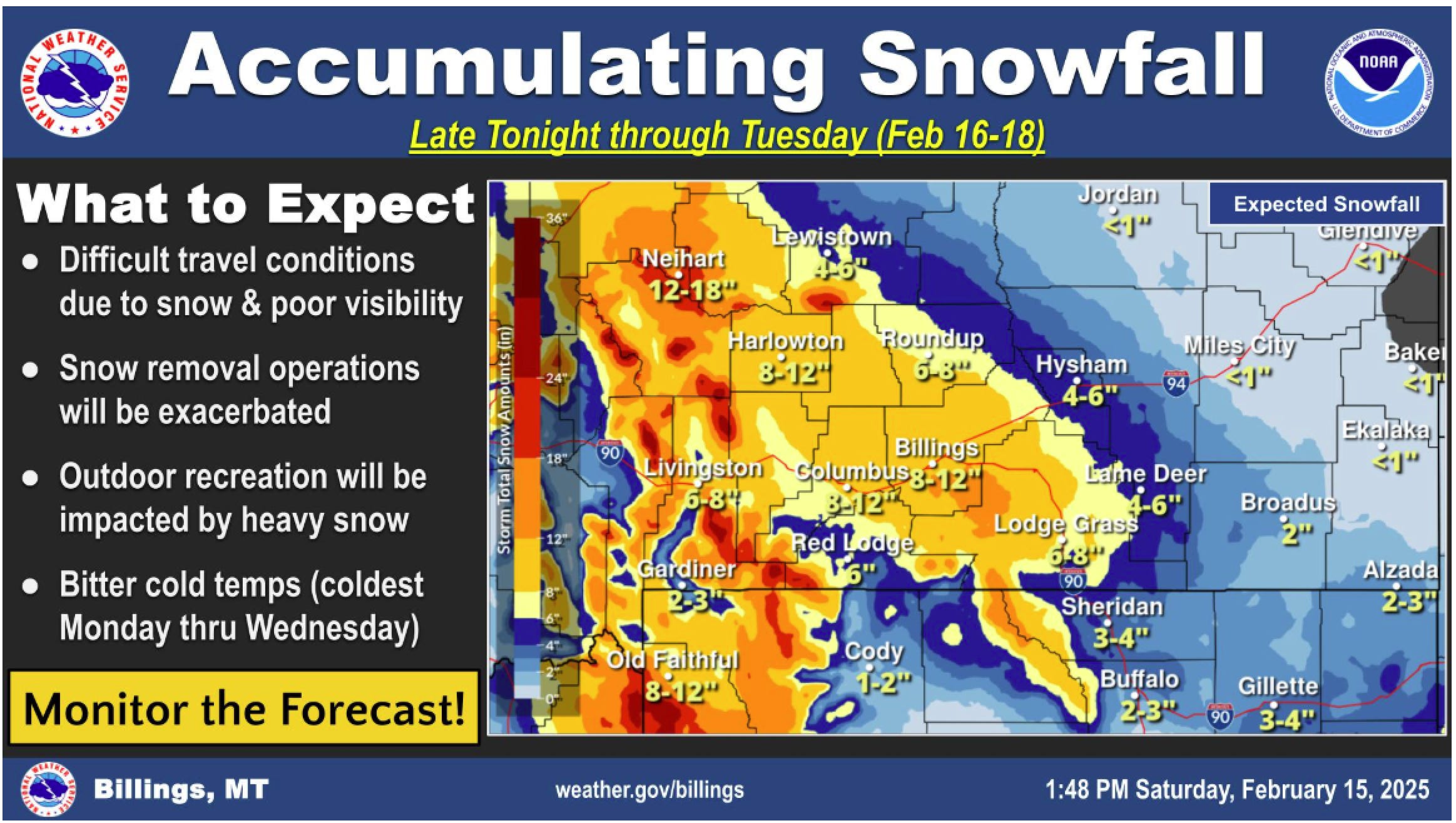
Greatest snowfall totals over central and western areas, with lesser totals into southeast Montana
Large swath of 6 to 12 inches of snowfall expected over and along a Harlowton to Billings to Lodge Grass line (50% chance for 12 or more inches of snowfall at Billings); 4 to 8 inches of snowfall down into the foothills
10 to 20 inches of snowfall expected in the Beartooth/Absaroka and Crazy mountains (greatest on west aspects); 7 to 14 inches in the Bighorn/Pryor mountains
Difficult travel conditions due to snow and poor visibility, impacting the Monday and Tuesday commutes
Significant amounts of snow exist across the area, the additional snow could exacerbate snow removal operations
Very cold temperatures and wind chill values Sunday through Wednesday
High temperatures: single digits above and below zero (coldest Tuesday)
Low temperatures: teens and 20s below zero (coldest Wednesday morning)
Probability of temperatures of -20 F or lower Wednesday morning is 50% or greater from Harlowton to Billings to Sheridan and areas north and east
Morning wind chills: 20s to 40s below zero (coldest Wednesday morning)
Cold weather preparedness
Dress in layers
Limit outdoor exposure
Protect livestock and pets
Warmup likely late next week
Moderating temperatures starting Thursday, with high temperatures in the 30s and 40s Friday and into next weekend
Above normal temperatures are likely to continue for several days with strong high pressure over the western US
Potential period of gusty foothills winds Friday and Saturday

