Two Spring Storm Systems This Week
By Denise Rivette
The Billings office of the National Weather Service has provided an overview of a couple of Spring storm systems to impact the area this week. Today into Tuesday a storm system will bring moderate rain to area foothills locations and locally heavy snow to area mountains. After a brief break another stronger system is expected to move into the area Wednesday afternoon. Details on this second system are still uncertain, but it has the potential for widespread moderate to locally heavy rainfall, and additional heavy mountain snowfall, through Friday. This activity will impact outdoor activities through the week and may impact activities stretching into the Stay tuned to the forecast through the week for more details.
DETAILS
Early Week Rainfall
Moderate Rainfall (0.50 to 1.0 in) possible foothills locations Today through Tuesday
A quarter of an inch or more possible along and south of I-90/US-212
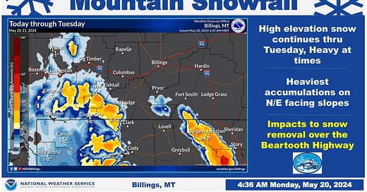
Heavy Mountain Snow through Tuesday
6 to 14 inches above 7000 feet with locally heavier possible
Heaviest on northeast facing slopes
Winter Storm Warning for the Beartooth/Absaroka mountains
Winter Weather Advisory for the Bighorn mountains
Heavy wet snow will impact the clearing of the Beartooth Highway
Potential Strong Spring Storm Wednesday-Friday
Potential for widespread 1-2 inch precipitation amounts lower elevations
Potential for heavy mountain snow
Storm track and timing still uncertain
Storm track will determine where heaviest precipitation will fall


