


Thunderstorms, Mountain Snowmelt, and Wet Weather System

From the Billings office of the National Weather Service

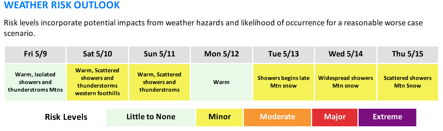
The Billings office of the National Weather Service has provided an outlook for the next week regarding potentially impactful weather.
KEY POINTS
Weekend showers and thunderstorms
Rises on small streams and rivers
Wet weather system mid week
Warm temperatures will bring snowmelt to area mountains resulting in strong rises to streams and creeks. While not likely at this time, minor flooding of smaller streams and creeks is possible. Use extra caution recreating on or near waterways as we head into the weekend.
A dynamic weather system will move into the area midweek bringing cooler, wetter weather.
DETAILS
Weekend Showers and Thunderstorms
Saturday- Showers with a few thunderstorms over the western foothills will be capable of producing wind gusts up to 60 mph.
Sunday- Isolated to scattered showers and thunderstorms with a few severe storms possible across southeast Montana.
Rises on Small Streams and Creeks
Warm temperatures through this weekend will allow for mountain snowmelt.
Increased flows can be expected along small streams and rivers. Those with interests along these areas should take the necessary precautions at this time.
No flooding is expected at this time. Keep an eye on the forecast for updates.
Rain on snow is possible with the thunderstorms Sunday.
Wet Weather System Midweek
Confidence is increasing for a low pressure system to bring widespread precipitation mid week.
Moderate chances for an inch of precipitation across the region Tuesday through Thursday.
Precipitation is expected to transition to snow Tuesday night for locations above 7,000 ft.
Impacts to the Beartooth Pass can be expected.

FOR MORE INFORMATION
For the latest forecast updates, visit weather.gov/billings