Strong Winds Sunday into Monday; Potential Winter Storm Monday into Tuesday
Weather Update from Billings office of the National Weather Service
Good morning everyone! With strong winds and precipitation in the forecast, we wanted to touch base with you all before the weekend.
KEY POINTS
Rain/Snow tapering off this morning
Strong winds are forecast over south-central Montana and northern Wyoming Sunday into Monday
Persistent snow in the mountains of south-central Montana this weekend through early next week
Rain transitioning to snow over the lower elevations Monday into Tuesday
For the most up to date forecast and product information, visit weather.gov/billings
DETAILS
Rain/Snow tapering off this morning
Minor winter impacts remain possible early this morning, mainly over the mountains and foothills.
Strong winds are forecast over south-central Montana and northern Wyoming Sunday into Monday
Over the lower elevations, the strongest winds are expected over the foothills west of Billings during the afternoon on Sunday
The chance of seeing a wind gust of 60 mph or greater is 60 percent around Livingston to Big Timber and 40 percent around Harlowton.
Locally higher wind gusts are possible over the foothills of the Beartooth and Bighorn Mountains Sunday night into early Monday morning.
This includes locations around Red Lodge, Montana and Sheridan, Wyoming.
At this time, confidence is low on this, but it is something to keep an eye on.
A frontal passage Monday will end the strong wind threat across the region.
See the "Strong Winds" graphic below for the current wind forecast.
Persistent snow in the mountains of south-central Montana this weekend through early next week.
Light to moderate snow through the weekend. Moderate to heavy snow possible Monday into Tuesday.
This snow will add to a snowpack that is around 90 to 100 percent of the annual average for this point in the snow season.
Moderate to heavy snow is possible over the Bighorn Mountains in north-central Wyoming Monday into Tuesday as well.
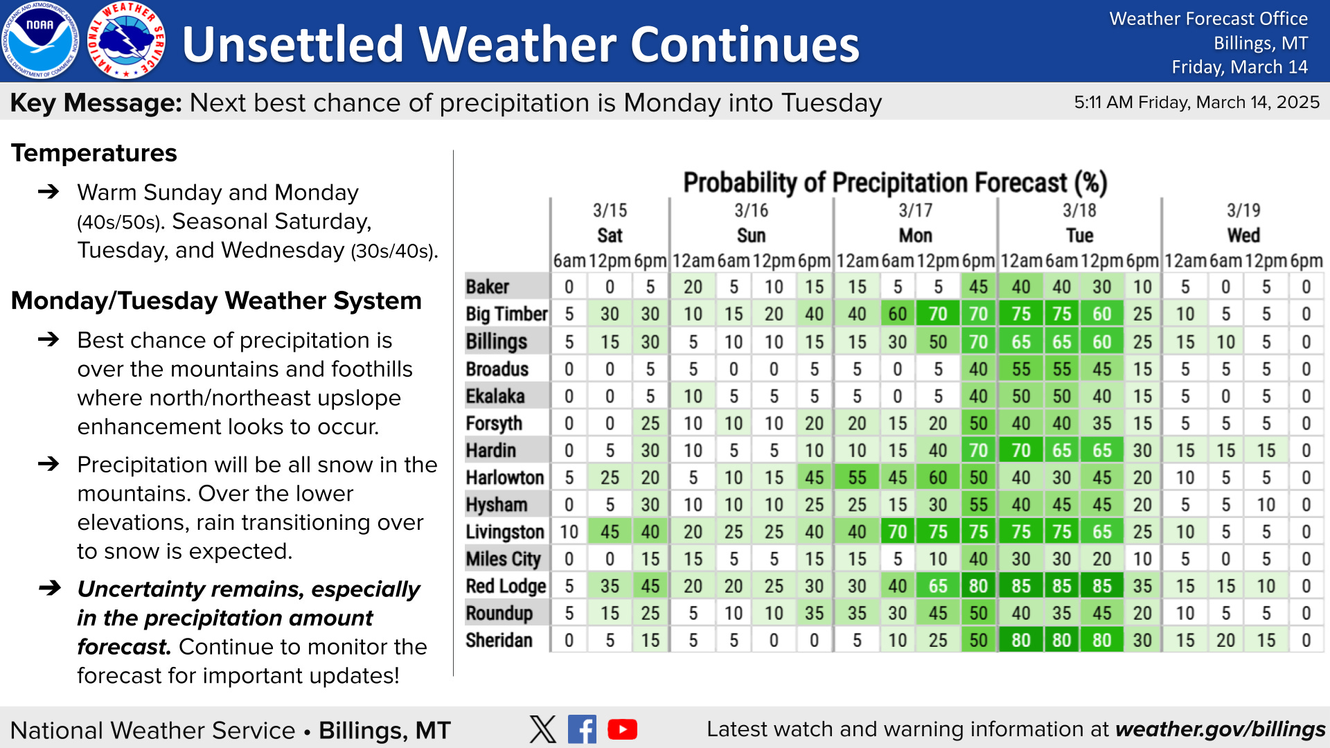
Rain transitioning to snow over the lower elevations Monday into Tuesday
A weather system will bring the chance of precipitation back across the region Monday into Tuesday.
At this time, the best chance of precipitation is over the mountains and foothills where upslope enhancement is likely to occur.
A good amount of uncertainty remains in the precipitation and subsequent snow forecast for this event. Therefore, it is important that you continue to monitor the forecast through the weekend for important updates.
See the "Weather Outlook" and "Snow Potential" graphics below for more information.


