Smoke Forecast
From Montana DEQ Monday morning forecast
Current Conditions
A stubborn ridge of high pressure will produce anomalously warm weather across the Northern Rockies this week. It will allow smoke from active wildfires burning in Idaho, Montana, and Wyoming to impact the Treasure State.
At 8:00 AM Monday, Libby, Columbia Falls, Great Falls, Frenchtown, Missoula, Sleeping Giant, Helena, Hamilton, Bozeman, Billings, and Broadus were enduring Moderate air quality. Butte was experiencing air that is Unhealthy for Sensitive Groups.
Monday morning’s satellite shows widespread smoke across much of the southern half of the state from regional wildfires.
Forecast
Numerous active wildfires continue to burn over Montana, Idaho, and Wyoming. These fires will send smoke into Montana at times, particularly the southwest part of the state. Expect the usual diurnal fluctuations in surface smoke. As winds die down in the evening, expect the smoke to drain and pool into adjacent valleys. The worst air quality in this pattern is usually in the morning to around midday. Once the inversions break up around midday, better mixing will gradually push the surface smoke out of the valleys, leading to better air quality.
Afternoon highs will climb 10-15 degrees above average through Wednesday. The combination of warm air, dry fuels, and gusty afternoon winds will allow the fires in the region to remain active, despite a weakening fall sun angle.
Unfortunately, forecast models have backed off on precipitation amounts with a front by the end of the week and into the weekend. Thus, regional wildfires will continue to pump smoke into much of Montana for the foreseeable future.
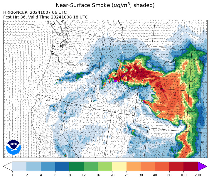
By late Tuesday, the HRRR smoke model shows high surface smoke concentrations over the state due to numerous active regional wildfires.
Source: HRRR Smoke


