MIN Weekly News Roundup
Week ending April 27, 2025


Officials throughout the county are keeping an eye on water levels and area conditions as this evening’s storm approaches. It is expected that smaller creeks and streams will have the highest potential for flooding. At this time, it is asked that everyone be aware of the potential dangers near waterways in in low lying areas and remove animals and equipment to higher ground.
Now is the time to get prepared. If you live near floodprone or burn scar areas, get your go-bags ready and have a plan. Let your friends and loved ones know your plan.
It is your responsibility to protect your private property. Government entities are responsible for saving lives and protecting public property. Make sure you have sandbags (Ace Hardware in Red Lodge has them in stock) if you may need them. Local governments may have extra sandbags, but they are only available after an emergency has been declared and their supply is limited.
And if you haven’t already, sign up for CodeRED HERE.
Please report any flooding to Carbon County Sheriff’s Dispatch at (406) 446-1234. If it is an emergency, call 911.
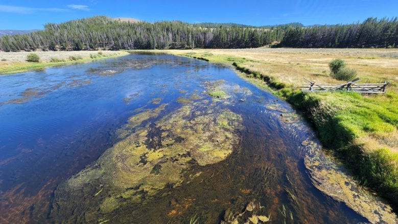
Flooding or Riparian Area Functioning Normally?
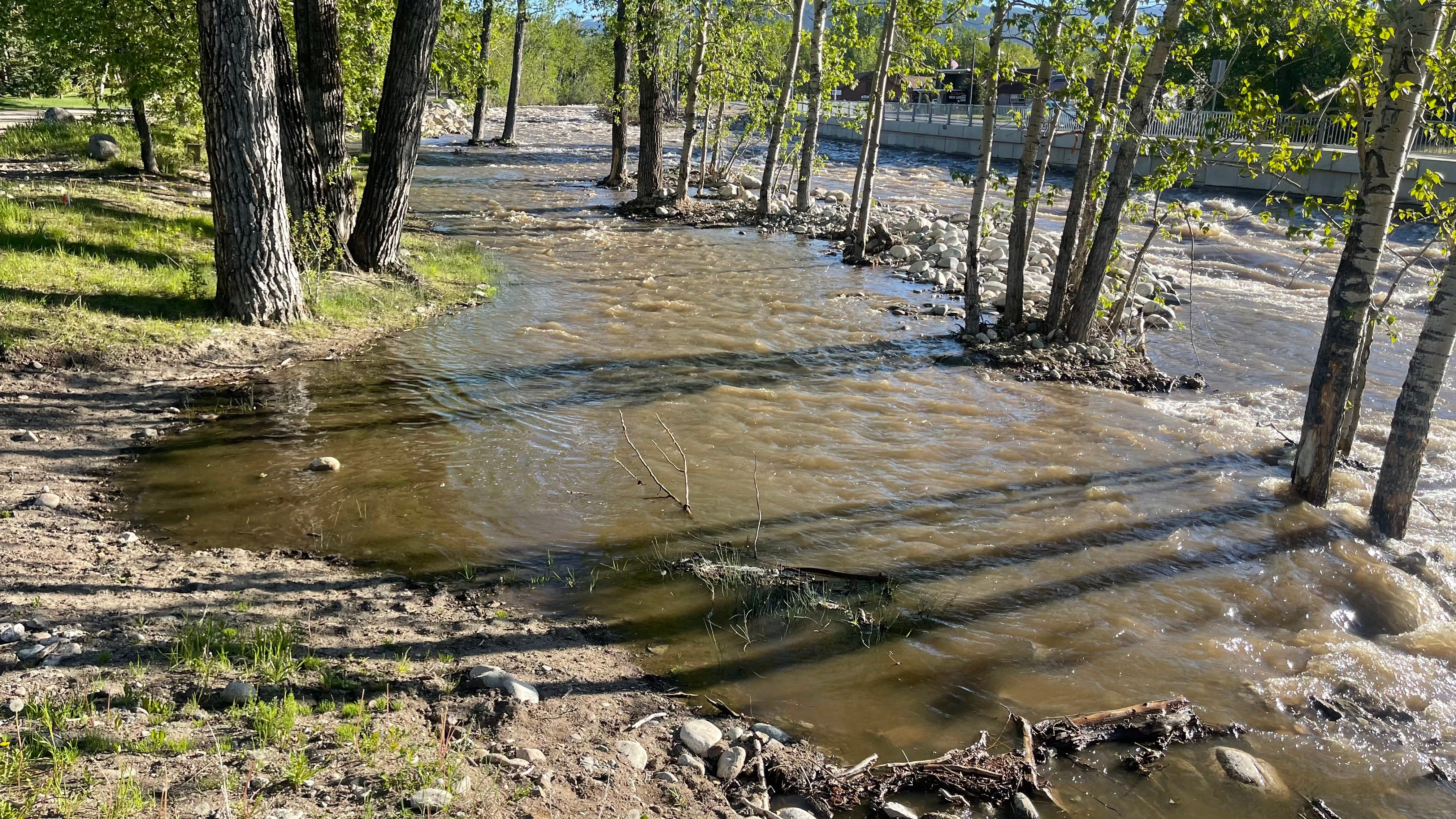
The above is a photo of a riparian zone functioning normally, not flooding dangerously in Red Lodge. Flooding is when water is where it is unexpected and likely to cause problems, such as near roadways. If you are in doubt, call it in at (406) 446-1234, the business line at Carbon County Sheriff’s Dispatch. If it looks like it could be an emergency, call 911.
You can keep an eye on local water levels at the links below:
Clarks Fork of the Yellowstone at Edgar
Rock Creek (South Central MT) near Red Lodge MT
West Fork Rock Creek near Red Lodge


Full Text of Alerts Issued by the National Weather Service Regarding Incoming Storm
Montana Independent News
Apr 27, 2025
Billings office of the National Weather Service Alerts issued at 2:13 this afternoon
Flood Watch
Flood Watch
National Weather Service Billings MT
213 PM MDT Sun Apr 27 2025

.Runoff from a combination of heavy rain and some mid elevation snow
melt may cause flooding of streams and low lying areas in and
downstream of the foothills. Burn Scars may produce flash flooding
in and downstream of the burned area.

MTZ034-040-056-064>068-139-141-170-172-282015-
/O.CON.KBYZ.FA.A.0001.250427T2100Z-250429T0000Z/
/00000.0.RS.000000T0000Z.000000T0000Z.000000T0000Z.OO/
Northern Stillwater-Northern Park-Red Lodge Foothills-Paradise
Valley-Livingston Area-Beartooth Foothills-Absaroka/Beartooth
Mountains-Crazy Mountains-Southeastern Carbon-Northern Sweet
Grass-Northern Carbon-Melville Foothills-
Including the locations of McLeod, Livingston, Columbus,
Emigrant, Big Timber, Bridger, Absarokee, Fromberg, Cooke City,
Clyde Park, Joliet, Melville, Fishtail, Red Lodge, and Wilsall
213 PM MDT Sun Apr 27 2025

...FLOOD WATCH REMAINS IN EFFECT THROUGH MONDAY AFTERNOON...

* WHAT...Flooding caused by rain and snowmelt remains a threat.

* WHERE...A portion of south central Montana, including the
  following areas, Absaroka/Beartooth Mountains, Beartooth
  Foothills, Crazy Mountains, Livingston Area, Melville Foothills,
  Northern Carbon, Northern Park, Northern Stillwater, Northern
  Sweet Grass, Paradise Valley, Red Lodge Foothills and Southeastern
  Carbon.

* WHEN...Through Monday afternoon.

* IMPACTS...Excessive runoff may result in flooding of streams and
  other low-lying and flood-prone locations close to the foothills.
  Some roads may become impassable.

* ADDITIONAL DETAILS...
  - Thunderstorms this afternoon will turn to more persistent
    rain this evening into the overnight hours. Snow levels
    dropping to 5000 ft Monday morning. Rain falling on snow may
    melt 1 to 3 inches of snow water before cooler temperatures
    change precipitation to snow ending the snowmelt.
  - http://www.weather.gov/safety/flood

PRECAUTIONARY/PREPAREDNESS ACTIONS...

You should monitor later forecasts and be alert for possible Flood
Warnings. Those living in areas prone to flooding should be prepared
to take action should flooding develop.

&&

$$
Winter Weather Advisory
URGENT - WINTER WEATHER MESSAGE
National Weather Service Billings MT
154 PM MDT Sun Apr 27 2025

MTZ056-066-282000-
/O.CON.KBYZ.WW.Y.0027.250428T0600Z-250429T0000Z/
Red Lodge Foothills-Beartooth Foothills-
Including the locations of Roscoe, McLeod, Nye, Fishtail,
Roberts, and Red Lodge
154 PM MDT Sun Apr 27 2025

...WINTER WEATHER ADVISORY REMAINS IN EFFECT FROM MIDNIGHT TONIGHT
TO 6 PM MDT MONDAY...

* WHAT...Wet snow expected. Total snow accumulations of 4-8 inches
  expected with up to 10 inches in the higher foothills. Winds
  gusting as high as 35 mph.

* WHERE...Beartooth Foothills and Red Lodge Foothills.

* WHEN...From midnight tonight to 6 PM MDT Monday.

* IMPACTS...Travel could be very difficult. Wet snow will create
  slushy road conditions. The hazardous conditions will impact the
  Monday morning and evening commutes.

* ADDITIONAL DETAILS...The greatest accumulations will be over
  grassy surfaces.

PRECAUTIONARY/PREPAREDNESS ACTIONS...

Slow down and use caution while traveling. For the latest road
conditions, call 5 1 1.