


Flood Advisory Downgrades To Flood Watch Tomorrow
Possible impacts include flooding and excessive erosion of banks

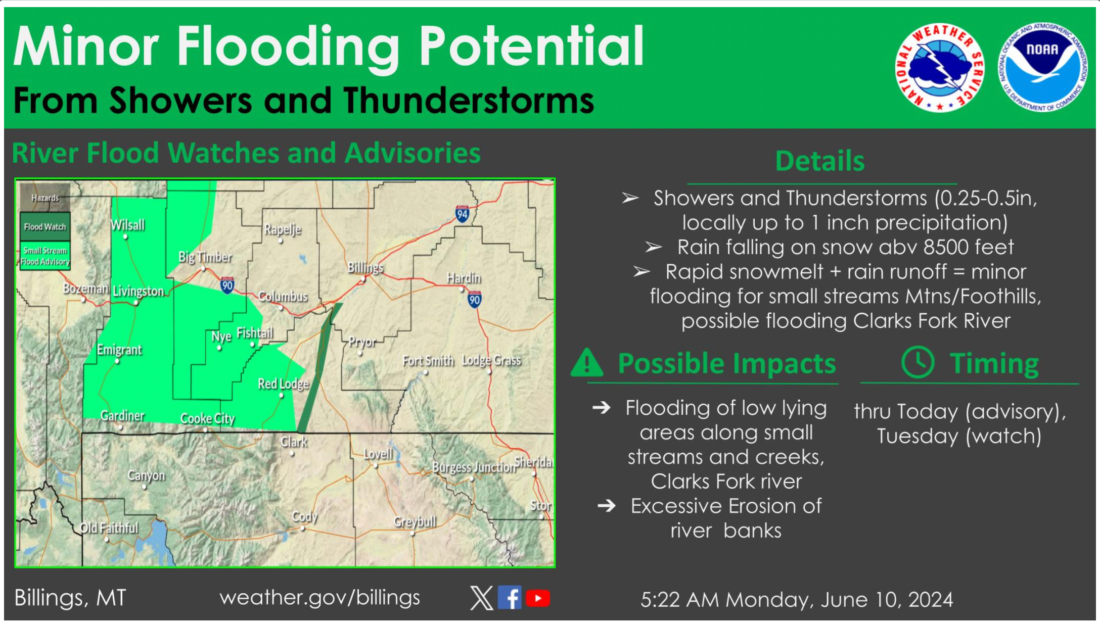
The Billings office of the National Weather Service reports radar estimates 0.5 to 1.00 inches of precipitation since last evening over the mountains. Additional rainfall is possible through this morning. The combination of extra runoff on already swollen streams will bring the potential for minor flooding of creeks and streams in the mountains and foothills where a Flood Advisory is in effect until Monday evening.
As this runoff moves down to the Clarks Fork, minor flooding is possible there as well and a Flood Watch is in effect for these locations.

FLOOD ADVISORY IN EFFECT UNTIL 6:30 PM MDT MONDAY THEN FLOOD WATCH THROUGH TUESDAY
WHAT...Small stream flooding caused by excessive rainfall and snowmelt is expected.
WHERE...Portions of central and south central Montana, including the following counties
In central Montana, southwestern Wheatland.
In south central Montana, southwestern Carbon, Park, southwestern Stillwater and Sweet Grass.
WHEN...Until 6:30 P.M. Monday
IMPACTS...Rapid rises on small streams and creeks originating in the mountains resulting in minor flooding adjacent to waterways. Runoff may flood roadways resulting in restriction to travel and possible foothills road damage.
ADDITIONAL DETAILS... - At 12:30 p.m., Streams are already running high with runoff, and thunderstorms are expected this afternoon through tonight. Rainfall forecast shows half an inch to locally an inch of rainfall is possible with thunderstorms through tonight. Above 8,500 feet this rain will fall on the snowpack resulting in increased snowmelt and extra runoff in addition to the precipitation forecast. This will cause rapid rises and small stream and creek flooding in the advisory area.
Some locations in the flood advisory include... Red Lodge, Clyde Park, Absarokee, Bearcreek, Chico Hot Springs, McLeod, Springdale, Nye, Pine Creek, Dean, Mystic Lake, Chico, Alpine, Emigrant, Melville, Fishtail, Jardine, Wilsall and Roscoe.
Campgrounds adjacent to waterways in mountains and foothills.
PRECAUTIONARY/PREPAREDNESS ACTIONS...
Turn around, don’t drown when encountering flooded roads find an alternate route. Roads and driveways may be damaged or washed out in places. Be especially cautious at night when it is harder to recognize the dangers of flooding.
Stay away or be swept away. Stream banks and culverts can become unstable and unsafe. It is important to know where you are relative to streams, rivers, or creeks which can become killers in heavy rains. Campers and hikers should avoid streams or creeks.
Please report observed flooding to local emergency officials at (406) 446-1234 and request they pass the information to the National Weather Service in Billings.