Extremely Dangerous Conditions for Young Livestock Throughout Region Midnight to 6:00 AM Monday
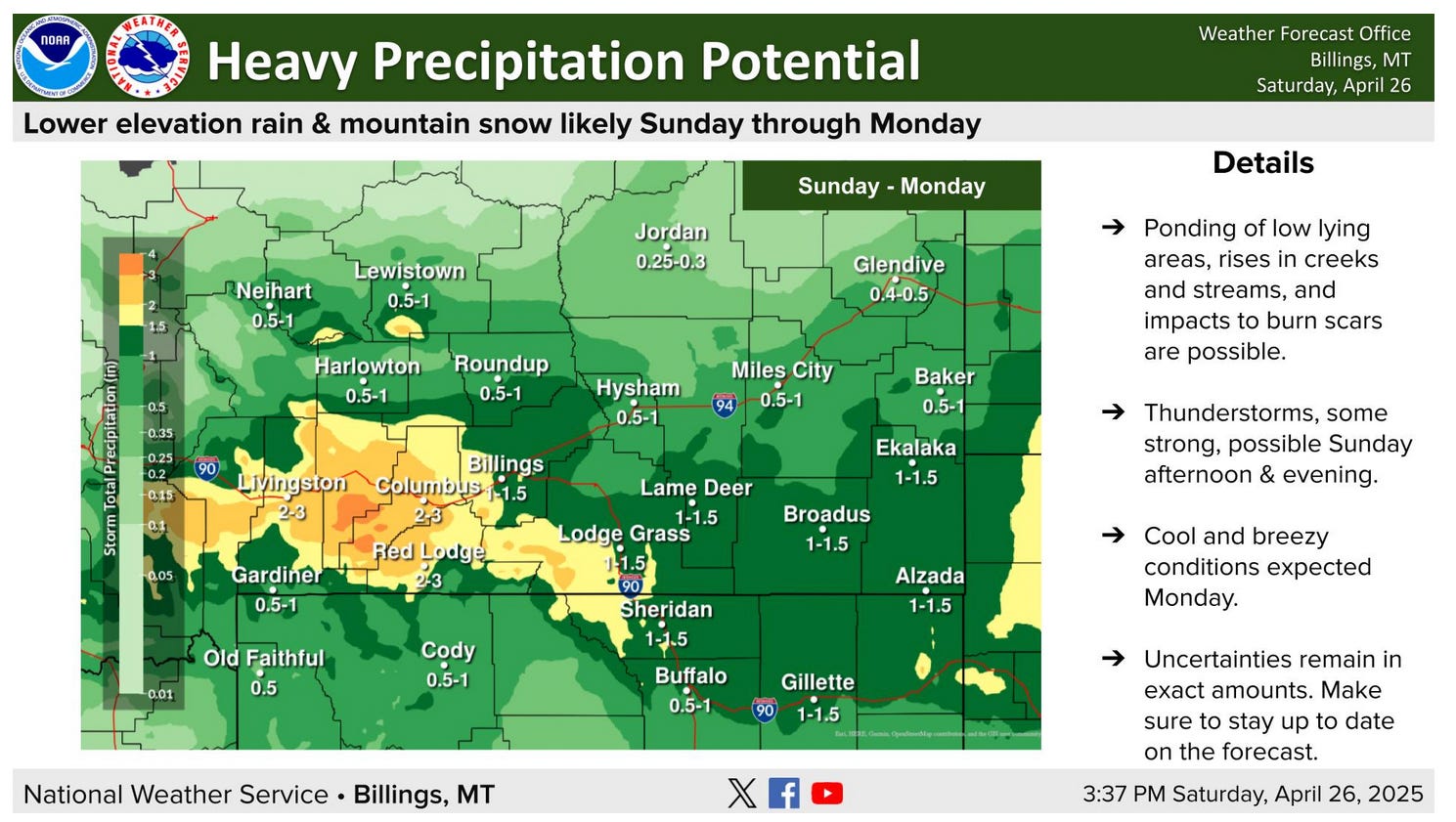
Sunday brings Spring storm and a flood watch; officials are monitoring waterways; now is the time to move livestock and equipment out of low lying areas and away from waterways
From the Billings office of the National Weather Service
Chilly, wet and windy conditions Sunday night and Monday may be hazardous for young livestock. Take precautions to protect your animals.
Another spring storm is taking shape for Sunday into Monday. Travel and outdoor recreation in the high country could become difficult due to snowy conditions. Stay up to date with the latest forecast if you have travel or outdoor plans during this time.
Ponding of low lying areas, rises in creeks and streams, and impacts to burn scars are possible.
A flood watch will be in effect from Sunday afternoon at 3:00 through Monday at 6:00 in the evening. Carbon County officials are monitoring waterways and the weather forecasts and will keep the pubic informed of any imminent danger through the CodeRED system and Carbon Alert. If you haven’t signed up for CodeRED yet, please click HERE or go to https://carbonalert.org/registration/ to register.
While flooding is not imminent, now is the time to move equipment and livestock out of low lying areas and away from waterways. If you are downstream from a burn scar, have an evacuation plan ready should conditions become dangerous. Do not drive over flooded roadways as the roadbed may be washed out. Be especially careful driving at night when water covered roadways are less visible.
* FLOOD WATCH

* WHEN...From Sunday afternoon through Monday afternoon.

* IMPACTS...Excessive runoff may result in minor flooding of streams
  and other low-lying and flood-prone locations close to the
  foothills. Some roads may become impassable. Now is the time to
  move equipment and livestock to higher ground away from waterways.
  Recent burn scars may be more susceptible to produce flooding,
  including the Robertson Draw south of Red Lodge.

* ADDITIONAL DETAILS...
  - Rain and high elevation snow is expected to develop Sunday
    afternoon and continue through Monday morning. Rainfall
    amounts are expected to range from 1 to 3 inches, while
    elevations above 7000 feet see heavy snow. There remains
    uncertainty regarding exact snow levels and how much snowmelt
    occurs with this system. Snow levels may fall enough to
    produce some wet snow at Red Lodge and Nye.
  - http://www.weather.gov/safety/flood

PRECAUTIONARY/PREPAREDNESS ACTIONS...

You should monitor later forecasts and be alert for possible Flood
Warnings. Those living in areas prone to flooding should be prepared
to take action should flooding develop.
...Foothills flooding possible late Sunday into Monday due to rain
falling on existing snowpack...

The latest snow data from the NRCS and NOHRSC shows a significant
snowpack existing between 5500 and 7500 feet. In this elevation 3 to
7 inches of water is contained within the snowpack. A storm system
is expected to impact the area from Sunday afternoon through Monday.
From Sunday afternoon into early Monday morning temperatures will be
warm enough for rain to fall in this mid elevation layer over the
Beartooth, Absaroka and Crazy mountains and foothills. The Pryor and
Bighorn mountains and foothills will see rain potential from late
Sunday evening into early afternoon Monday. A few thunderstorms may
bring locally heavy rainfall Sunday afternoon into Sunday evening.

Snowmelt models are estimating half of this mid elevation snowpack
could melt out during the rainfall period. With 1 to 2 inches of
rain in the forecast, this means an additional 1.5 to 3.5 inches of
water contribution from snowmelt. Total water event could be 2.5 to
5.5 inches if these forecasts are correct.

Anywhere snowpack is present, the ground underneath is likely frozen
resulting in quick runoff until reaching unfrozen ground at lower
elevations. Burn scar areas will also see rapid runoff due to burnt
soil conditions, including the Robertson Draw, American Fork, and
Elk burn areas.

Smaller creeks and streams will see the highest potential for
flooding with this event. Forecasts for the larger rivers in our
area show up to 3 times the current flows by Tuesday, though water
levels remain well below flood stage. Water may flow overland and
across roadways creating difficult to dangerous foothills travel.
Low lying areas may fill with water creating additional property
flooding.

The severity of the impacts will depend on how quickly and how much
the snowpack melts, in addition to the amount of rain that falls on
top of the snowpack.

While flooding is not imminent, now is the time to move equipment
and livestock out of low lying areas, and away from waterways. If
you are downstream from a burn scar, have an evacuation plan ready
should conditions become dangerous. Do not drive over flooded
roadways as the roadbed may be washed out. Be especially careful
driving at night when water covered roadways are less visible.

This period is not a good time to recreate in the foothills, but
anyone that is recreating in these areas should expect changing
conditions and use extreme caution near waterways. Do not camp in
low lying areas adjacent to streams.

There is still uncertainty with this storm system. Stay tuned to the
forecast through the weekend for the latest trends, along with any
watches, warnings or advisories that may be issued. Please report
any flooding to local law enforcement and have them relay the report
to the National Weather Service.


A reminder that far more livestock are lost to weather (including increasingly unpredictable and extreme weather events due to man-caused climate change) and infection than to predators.